Beelen night lights from space
Night Light of Beelen (North Rhine-Westphalia) from space (Germany) Src. Average luminocity for 10x10km area is 0.2677% and for 50x50km: 4.2868%.
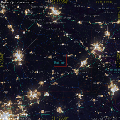
Analysis of Beelen night lights 2016
Square area 10x10 km:
 0%
0%90-99
0%80-89
0%70-79
0%60-69
0.25%50-59
0%40-49
0%30-39
0%20-29
0.13%10-19
0.13%0-9
99.49%Square area 50x50 km:
0.24%90-99
0.42%80-89
0.33%70-79
0.3%60-69
0.73%50-59
0.88%40-49
0.95%30-39
0.64%20-29
0.88%10-19
3.67%0-9
90.96%Clear (daylight) street map image can be seen on geolist.org.
Map coordinates:
52° 21' 37.9" North, 7° 24' 28.9" East
51° 55' 44.6" North, 8° 6' 40.2" East
51° 29' 36.2" North, 8° 48' 51.4" East
Some cities around Beelen sort by population:
• Rheda-Wiedenbrück
15.7 km =9.8 mi,  124°
124°
• Warendorf
8.8 km =5.5 mi,  286°
286°
• Oelde
11.4 km =7.1 mi,  167°
167°
• Harsewinkel
8.8 km =5.5 mi,  65°
65°
• Versmold
12.7 km =7.9 mi,  12°
12°
• Ennigerloh
11.5 km =7.1 mi,  208°
208°
• Sassenberg
8.5 km =5.3 mi,  325°
325°
• Everswinkel
18.1 km =11.2 mi,  268°
268°
2951596 (p: 6,344)
Sources (retrieved 2019-11-25):
» Earth at Night: Flat Maps 2012, 2016