Oedheim night lights from space
Night Light of Oedheim (Baden-Württemberg) from space (Germany) Src. Average luminocity for 10x10km area is 15.3155% and for 50x50km: 6.4692%.
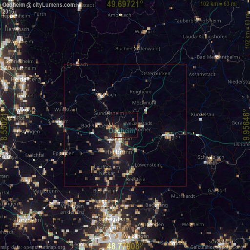
Analysis of Oedheim night lights 2016
Square area 10x10 km:
 1.74%
1.74%90-99
1.47%80-89
0.8%70-79
0.8%60-69
2.81%50-59
4.14%40-49
2.14%30-39
2.27%20-29
4.68%10-19
14.84%0-9
64.3%Square area 50x50 km:
0.72%90-99
0.65%80-89
0.55%70-79
0.66%60-69
0.83%50-59
1.25%40-49
1.03%30-39
1.17%20-29
1.65%10-19
4.49%0-9
87%Clear (daylight) street map image can be seen on geolist.org.
Map coordinates:
49° 41' 50" North, 8° 33' 0.8" East
49° 14' 25" North, 9° 15' 12" East
48° 46' 44.7" North, 9° 57' 23.3" East
Some cities around Oedheim sort by population:
• Heilbronn
11.4 km =7.1 mi,  192°
192°
• Neckarsulm
6 km =3.7 mi,  199°
199°
• Bad Rappenau
11 km =6.8 mi,  268°
268°
• Weinsberg
10.2 km =6.3 mi,  165°
165°
• Neuenstadt am Kocher
5.8 km =3.6 mi,  95°
95°
• Gundelsheim
8.3 km =5.2 mi,  305°
305°
• Bad Wimpfen
7.1 km =4.4 mi,  260°
260°
• Neudenau
5.9 km =3.7 mi,  11°
11°
2857967 (p: 5,921)
Sources (retrieved 2019-11-25):
» Earth at Night: Flat Maps 2012, 2016