Gundelsheim night lights from space
Night Light of Gundelsheim (Baden-Württemberg) from space (Germany) Src. Average luminocity for 10x10km area is 6.5094% and for 50x50km: 6.3775%.
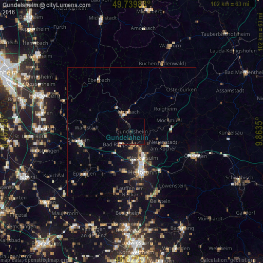
Analysis of Gundelsheim night lights 2016
Square area 10x10 km:
 0.53%
0.53%90-99
0.53%80-89
0%70-79
0%60-69
1.07%50-59
0.8%40-49
0.94%30-39
1.34%20-29
0.53%10-19
6.15%0-9
88.1%Square area 50x50 km:
0.78%90-99
0.74%80-89
0.46%70-79
0.62%60-69
0.89%50-59
1.18%40-49
0.93%30-39
1.27%20-29
1.62%10-19
4.13%0-9
87.37%Clear (daylight) street map image can be seen on geolist.org.
Map coordinates:
49° 44' 23.4" North, 8° 27' 26.1" East
49° 16' 59.9" North, 9° 9' 37.3" East
48° 49' 21" North, 9° 51' 48.6" East
Some cities around Gundelsheim sort by population:
• Neckarsulm
11.5 km =7.1 mi,  155°
155°
• Mosbach
7.8 km =4.8 mi,  355°
355°
• Bad Rappenau
6.5 km =4 mi,  220°
220°
• Bad Wimpfen
6 km =3.7 mi,  182°
182°
• Oedheim
8.3 km =5.2 mi,  125°
125°
• Billigheim
9.9 km =6.2 mi,  43°
43°
• Obrigheim
9.1 km =5.7 mi,  326°
326°
• Neudenau
8 km =5 mi,  83°
83°
2913693 (p: 7,551)
Sources (retrieved 2019-11-25):
» Earth at Night: Flat Maps 2012, 2016