Bad Schwalbach night lights from space
Night Light of Bad Schwalbach (Hesse) from space (Germany) Src. Average luminocity for 10x10km area is 2.635% and for 50x50km: 11.6636%.
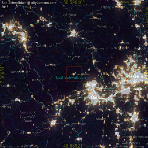
Analysis of Bad Schwalbach night lights 2016
Square area 10x10 km:
 0.27%
0.27%90-99
0.27%80-89
0.27%70-79
0.53%60-69
0.27%50-59
0.13%40-49
0.67%30-39
0.8%20-29
0%10-19
0.53%0-9
96.26%Square area 50x50 km:
2.28%90-99
2.35%80-89
0.95%70-79
1.03%60-69
1.03%50-59
1.07%40-49
1.59%30-39
2.13%20-29
3.68%10-19
8.25%0-9
75.63%Clear (daylight) street map image can be seen on geolist.org.
Map coordinates:
50° 35' 25.7" North, 7° 21' 59.4" East
50° 8' 31.1" North, 8° 4' 10.7" East
49° 41' 21.2" North, 8° 46' 21.9" East
Some cities around Bad Schwalbach sort by population:
• Wiesbaden
14.4 km =8.9 mi,  117°
117°
• Taunusstein
5.9 km =3.7 mi,  81°
81°
• Idstein
16.4 km =10.2 mi,  59°
59°
• Eltville
13.1 km =8.1 mi,  164°
164°
• Niedernhausen
17.5 km =10.9 mi, 82°
• Budenheim
15.6 km =9.7 mi,  153°
153°
• Schlangenbad
5.9 km =3.7 mi, 156°
• Walluf
12.9 km =8 mi, 151°
2953348 (p: 11,112)
Sources (retrieved 2019-11-25):
» Earth at Night: Flat Maps 2012, 2016