Eltville night lights from space
Night Light of Eltville (Hesse) from space (Germany) Src. Average luminocity for 10x10km area is 21.7031% and for 50x50km: 14.6536%.
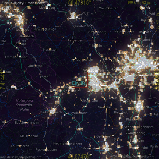
Analysis of Eltville night lights 2016
Square area 10x10 km:
 0.84%
0.84%90-99
1.96%80-89
3.08%70-79
1.12%60-69
2.38%50-59
3.36%40-49
4.34%30-39
6.72%20-29
8.4%10-19
30.95%0-9
36.83%Square area 50x50 km:
2.71%90-99
2.83%80-89
1.27%70-79
1.29%60-69
1.25%50-59
1.47%40-49
2%30-39
2.33%20-29
5.03%10-19
10.74%0-9
69.07%Clear (daylight) street map image can be seen on geolist.org.
Map coordinates:
50° 28' 41.3" North, 7° 24' 51.9" East
50° 1' 42.9" North, 8° 7' 3.1" East
49° 34' 29.1" North, 8° 49' 14.4" East
Some cities around Eltville sort by population:
• Wiesbaden
11.2 km =7 mi,  57°
57°
• Ingelheim am Rhein
7.7 km =4.8 mi,  213°
213°
• Nieder-Ingelheim
6.5 km =4 mi, 209°
• Geisenheim
11.7 km =7.3 mi,  245°
245°
• Budenheim
3.8 km =2.4 mi,  110°
110°
• Gau-Algesheim
10.8 km =6.7 mi,  222°
222°
• Schlangenbad
7.3 km =4.5 mi,  351°
351°
• Walluf
3 km =1.9 mi, 64°
2930646 (p: 16,845)
Sources (retrieved 2019-11-25):
» Earth at Night: Flat Maps 2012, 2016