Budenheim night lights from space
Night Light of Budenheim (Rheinland-Pfalz) from space (Germany) Src. Average luminocity for 10x10km area is 43.0028% and for 50x50km: 17.4017%.
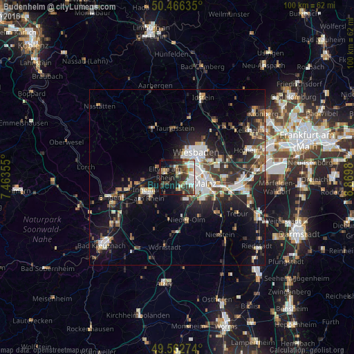
Analysis of Budenheim night lights 2016
Square area 10x10 km:
 9.38%
9.38%90-99
9.52%80-89
3.08%70-79
2.94%60-69
4.34%50-59
4.2%40-49
8.68%30-39
13.03%20-29
7.84%10-19
23.53%0-9
13.45%Square area 50x50 km:
3.04%90-99
3.29%80-89
1.53%70-79
1.67%60-69
1.62%50-59
1.91%40-49
2.4%30-39
2.95%20-29
6.1%10-19
12.95%0-9
62.54%Clear (daylight) street map image can be seen on geolist.org.
Map coordinates:
50° 27' 58.9" North, 7° 27' 48.8" East
50° 1' 0" North, 8° 10' 0" East
49° 33' 45.9" North, 8° 52' 11.3" East
Some cities around Budenheim sort by population:
• Wiesbaden
9.4 km =5.8 mi,  38°
38°
• Mainz
8.8 km =5.5 mi,  114°
114°
• Ingelheim am Rhein
9.2 km =5.7 mi,  236°
236°
• Nieder-Ingelheim
8 km =5 mi, 237°
• Eltville
3.8 km =2.4 mi,  290°
290°
• Nieder-Olm
12 km =7.5 mi,  166°
166°
• Schlangenbad
9.6 km =6 mi,  331°
331°
• Walluf
2.7 km =1.7 mi,  342°
342°
2942087 (p: 8,598)
Sources (retrieved 2019-11-25):
» Earth at Night: Flat Maps 2012, 2016