Walluf night lights from space
Night Light of Walluf (Hesse) from space (Germany) Src. Average luminocity for 10x10km area is 41.1835% and for 50x50km: 16.5778%.
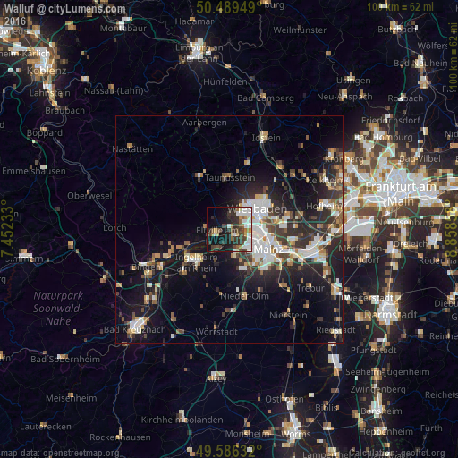
Analysis of Walluf night lights 2016
Square area 10x10 km:
 10.22%
90-99
9.1%80-89
2.38%70-79
2.94%60-69
3.36%50-59
5.46%40-49
7%30-39
9.8%20-29
9.1%10-19
21.01%0-9
19.61%Square area 50x50 km:
2.92%90-99
3.16%80-89
1.45%70-79
1.58%60-69
1.51%50-59
1.79%40-49
2.27%30-39
2.83%20-29
5.88%10-19
12.05%0-9
64.55%Clear (daylight) street map image can be seen on geolist.org.
Map coordinates:
50° 29' 22.2" North, 7° 27' 8.4" East
50° 2' 24.1" North, 8° 9' 19.6" East
49° 35' 10.8" North, 8° 51' 30.9" East
Some cities around Walluf sort by population:
• Wiesbaden
8.2 km =5.1 mi,  54°
54°
• Mainz
10.8 km =6.7 mi,  125°
125°
• Taunusstein
12.2 km =7.6 mi,  358°
358°
• Ingelheim am Rhein
10.3 km =6.4 mi,  221°
221°
• Nieder-Ingelheim
9.1 km =5.7 mi, 220°
• Eltville
3 km =1.9 mi,  244°
244°
• Budenheim
2.7 km =1.7 mi,  162°
162°
• Schlangenbad
7 km =4.3 mi,  327°
327°
3208134 (p: 5,698)
Sources (retrieved 2019-11-25):
» Earth at Night: Flat Maps 2012, 2016