Schlangenbad night lights from space
Night Light of Schlangenbad (Hesse) from space (Germany) Src. Average luminocity for 10x10km area is 4.5798% and for 50x50km: 13.3297%.
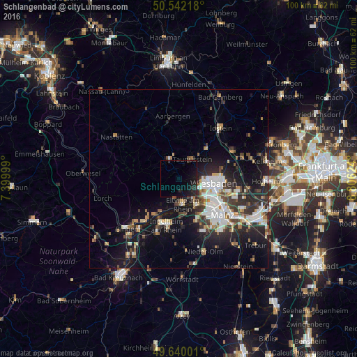
Analysis of Schlangenbad night lights 2016
Square area 10x10 km:
 0%
0%90-99
0%80-89
0%70-79
0%60-69
0%50-59
0%40-49
0%30-39
1.4%20-29
3.36%10-19
10.78%0-9
84.45%Square area 50x50 km:
2.47%90-99
2.62%80-89
1.15%70-79
1.19%60-69
1.12%50-59
1.32%40-49
1.81%30-39
2.28%20-29
4.4%10-19
9.84%0-9
71.81%Clear (daylight) street map image can be seen on geolist.org.
Map coordinates:
50° 32' 31.8" North, 7° 23' 60" East
50° 5' 35.6" North, 8° 6' 11.2" East
49° 38' 24" North, 8° 48' 22.5" East
Some cities around Schlangenbad sort by population:
• Wiesbaden
10.5 km =6.5 mi,  96°
96°
• Taunusstein
7.2 km =4.5 mi,  28°
28°
• Ingelheim am Rhein
14 km =8.7 mi,  193°
193°
• Nieder-Ingelheim
13 km =8.1 mi, 189°
• Eltville
7.3 km =4.5 mi,  171°
171°
• Bad Schwalbach
5.9 km =3.7 mi,  336°
336°
• Budenheim
9.6 km =6 mi,  151°
151°
• Walluf
7 km =4.3 mi, 147°
2838918 (p: 6,265)
Sources (retrieved 2019-11-25):
» Earth at Night: Flat Maps 2012, 2016