Heimsheim night lights from space
Night Light of Heimsheim (Baden-Württemberg) from space (Germany) Src. Average luminocity for 10x10km area is 17.9048% and for 50x50km: 21.1268%.
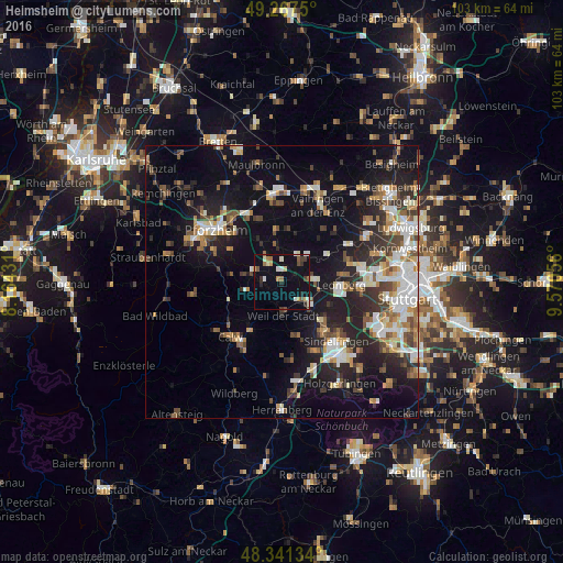
Analysis of Heimsheim night lights 2016
Square area 10x10 km:
 0.99%
0.99%90-99
3.69%80-89
2.13%70-79
1.7%60-69
2.84%50-59
1.28%40-49
2.41%30-39
2.7%20-29
2.13%10-19
11.79%0-9
68.32%Square area 50x50 km:
3.31%90-99
3.97%80-89
1.76%70-79
2.31%60-69
2.72%50-59
2.37%40-49
2.96%30-39
3.05%20-29
6.4%10-19
14.46%0-9
56.69%Clear (daylight) street map image can be seen on geolist.org.
Map coordinates:
49° 16' 3" North, 8° 9' 51.5" East
48° 48' 23.6" North, 8° 52' 2.8" East
48° 20' 28.8" North, 9° 34' 14" East
Some cities around Heimsheim sort by population:
• Weil der Stadt
6.3 km =3.9 mi,  177°
177°
• Renningen
6.6 km =4.1 mi,  128°
128°
• Rutesheim
5.7 km =3.5 mi,  88°
88°
• Magstadt
10 km =6.2 mi, 133°
• Weissach
6.3 km =3.9 mi,  44°
44°
• Wiernsheim
8.6 km =5.3 mi,  351°
351°
• Tiefenbronn
5.2 km =3.2 mi,  291°
291°
• Neuhausen
6.8 km =4.2 mi,  256°
256°
2907359 (p: 5,234)
Sources (retrieved 2019-11-25):
» Earth at Night: Flat Maps 2012, 2016