Bad Camberg night lights from space
Night Light of Bad Camberg (Hesse) from space (Germany) Src. Average luminocity for 10x10km area is 2.9759% and for 50x50km: 9.6981%.
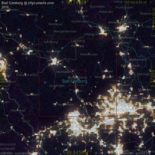
Analysis of Bad Camberg night lights 2016
Square area 10x10 km:
 0%
0%90-99
0%80-89
0%70-79
0.53%60-69
0%50-59
1.07%40-49
0%30-39
2.27%20-29
2.01%10-19
0.53%0-9
93.58%Square area 50x50 km:
1.73%90-99
1.8%80-89
1.01%70-79
1.11%60-69
1.08%50-59
1.12%40-49
1.54%30-39
1.38%20-29
2.24%10-19
5.37%0-9
81.6%Clear (daylight) street map image can be seen on geolist.org.
Map coordinates:
50° 44' 38.4" North, 7° 33' 57" East
50° 17' 49" North, 8° 16' 8.3" East
49° 50' 44.4" North, 8° 58' 19.5" East
Some cities around Bad Camberg sort by population:
• Idstein
8.8 km =5.5 mi,  181°
181°
• Neu-Anspach
16.6 km =10.3 mi,  82°
82°
• Niedernhausen
15.2 km =9.4 mi,  168°
168°
• Runkel
14.6 km =9.1 mi,  326°
326°
• Schmitten
13.3 km =8.3 mi,  104°
104°
• Villmar
11.9 km =7.4 mi, 333°
• Waldems
6.9 km =4.3 mi,  138°
138°
• Glashütten
12.9 km =8 mi,  133°
133°
2940381 (p: 14,195)
Sources (retrieved 2019-11-25):
» Earth at Night: Flat Maps 2012, 2016