Villmar night lights from space
Night Light of Villmar (Hesse) from space (Germany) Src. Average luminocity for 10x10km area is 1.3683% and for 50x50km: 3.5375%.
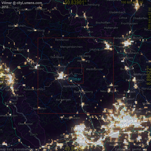
Analysis of Villmar night lights 2016
Square area 10x10 km:
 0%
0%90-99
0%80-89
0%70-79
0.84%60-69
0.28%50-59
0%40-49
0%30-39
0.28%20-29
0%10-19
0.56%0-9
98.04%Square area 50x50 km:
0.36%90-99
0.49%80-89
0.25%70-79
0.5%60-69
0.46%50-59
0.45%40-49
0.47%30-39
0.56%20-29
0.75%10-19
2.77%0-9
92.94%Clear (daylight) street map image can be seen on geolist.org.
Map coordinates:
50° 50' 20.4" North, 7° 29' 23.9" East
50° 23' 34.3" North, 8° 11' 35.2" East
49° 56' 33" North, 8° 53' 46.4" East
Some cities around Villmar sort by population:
• Limburg an der Lahn
10.2 km =6.3 mi,  264°
264°
• Bad Camberg
11.9 km =7.4 mi,  153°
153°
• Weilburg
11.3 km =7 mi,  25°
25°
• Hadamar
12.2 km =7.6 mi,  298°
298°
• Diez
13.3 km =8.3 mi, 261°
• Runkel
3.1 km =1.9 mi, 297°
• Weilmünster
13.7 km =8.5 mi,  71°
71°
• Elz
11.6 km =7.2 mi,  283°
283°
2817217 (p: 7,334)
Sources (retrieved 2019-11-25):
» Earth at Night: Flat Maps 2012, 2016