Neu-Anspach night lights from space
Night Light of Neu-Anspach (Hesse) from space (Germany) Src. Average luminocity for 10x10km area is 7.127% and for 50x50km: 14.579%.
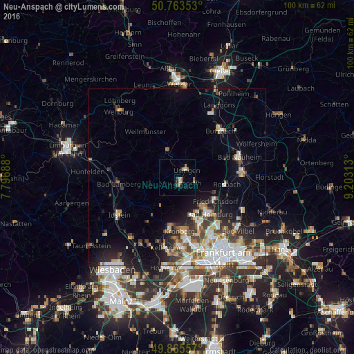
Analysis of Neu-Anspach night lights 2016
Square area 10x10 km:
 0%
0%90-99
1.2%80-89
1.47%70-79
1.34%60-69
1.47%50-59
0.4%40-49
1.07%30-39
0.53%20-29
0.53%10-19
0.53%0-9
91.44%Square area 50x50 km:
3.29%90-99
3.02%80-89
1.39%70-79
1.49%60-69
1.53%50-59
1.36%40-49
1.98%30-39
2.29%20-29
3.34%10-19
5.83%0-9
74.48%Clear (daylight) street map image can be seen on geolist.org.
Map coordinates:
50° 45' 48.7" North, 7° 47' 48.8" East
50° 19' 0" North, 8° 30' 0" East
49° 51' 56.1" North, 9° 12' 11.3" East
Some cities around Neu-Anspach sort by population:
• Bad Homburg vor der Höhe
13 km =8.1 mi,  139°
139°
• Oberursel
13.3 km =8.3 mi,  155°
155°
• Friedrichsdorf
12.6 km =7.8 mi,  126°
126°
• Usingen
3.4 km =2.1 mi,  51°
51°
• Wehrheim
5.1 km =3.2 mi,  111°
111°
• Schmitten
6.6 km =4.1 mi,  212°
212°
• Glashütten
13.2 km =8.2 mi, 212°
• Grävenwiesbach
8.7 km =5.4 mi,  339°
339°
2866280 (p: 15,276)
Sources (retrieved 2019-11-25):
» Earth at Night: Flat Maps 2012, 2016