Glashütten night lights from space
Night Light of Glashütten (Hesse) from space (Germany) Src. Average luminocity for 10x10km area is 4.7914% and for 50x50km: 23.8705%.
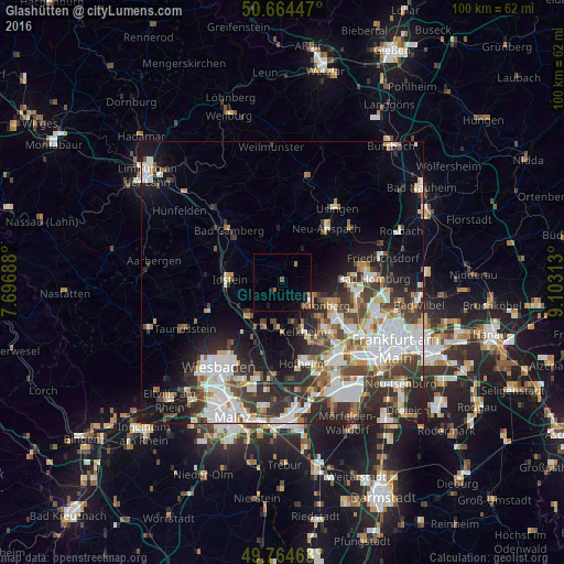
Analysis of Glashütten night lights 2016
Square area 10x10 km:
 0.4%
0.4%90-99
0.13%80-89
0%70-79
0%60-69
1.87%50-59
0.8%40-49
1.07%30-39
0%20-29
1.34%10-19
2.81%0-9
91.58%Square area 50x50 km:
5.92%90-99
5.46%80-89
1.95%70-79
2.03%60-69
2.38%50-59
2.24%40-49
3.47%30-39
4.29%20-29
6.72%10-19
8.07%0-9
57.46%Clear (daylight) street map image can be seen on geolist.org.
Map coordinates:
50° 39' 52.1" North, 7° 41' 48.8" East
50° 13' 0" North, 8° 24' 0" East
49° 45' 52.7" North, 9° 6' 11.3" East
Some cities around Glashütten sort by population:
• Kelkheim (Taunus)
9.5 km =5.9 mi,  158°
158°
• Kronberg
9.5 km =5.9 mi,  112°
112°
• Kronberg Tal
8.5 km =5.3 mi,  119°
119°
• Königstein im Taunus
6.6 km =4.1 mi,  129°
129°
• Niedernhausen
8.6 km =5.3 mi,  225°
225°
• Eppstein
8.2 km =5.1 mi,  183°
183°
• Schmitten
6.6 km =4.1 mi,  32°
32°
• Waldems
6 km =3.7 mi,  308°
308°
2920085 (p: 5,382)
Sources (retrieved 2019-11-25):
» Earth at Night: Flat Maps 2012, 2016