Schmitten night lights from space
Night Light of Schmitten (Hesse) from space (Germany) Src. Average luminocity for 10x10km area is 4.1203% and for 50x50km: 19.5669%.
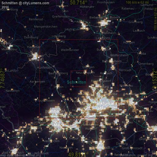
Analysis of Schmitten night lights 2016
Square area 10x10 km:
 0%
0%90-99
0.53%80-89
0.8%70-79
0.8%60-69
0.53%50-59
0.27%40-49
0.53%30-39
0.27%20-29
0.53%10-19
1.6%0-9
94.12%Square area 50x50 km:
4.68%90-99
4.28%80-89
1.76%70-79
1.86%60-69
2.01%50-59
1.92%40-49
2.86%30-39
3.5%20-29
4.64%10-19
6.47%0-9
66.03%Clear (daylight) street map image can be seen on geolist.org.
Map coordinates:
50° 42' 50.4" North, 7° 44' 48.7" East
50° 16' 0" North, 8° 27' 0" East
49° 48' 54.4" North, 9° 9' 11.2" East
Some cities around Schmitten sort by population:
• Kronberg
10.5 km =6.5 mi,  150°
150°
• Kronberg Tal
10.4 km =6.5 mi,  158°
158°
• Königstein im Taunus
9.8 km =6.1 mi,  171°
171°
• Neu-Anspach
6.6 km =4.1 mi,  32°
32°
• Usingen
9.8 km =6.1 mi,  38°
38°
• Wehrheim
9.1 km =5.7 mi,  65°
65°
• Waldems
8.5 km =5.3 mi,  257°
257°
• Glashütten
6.6 km =4.1 mi,  212°
212°
2837706 (p: 9,042)
Sources (retrieved 2019-11-25):
» Earth at Night: Flat Maps 2012, 2016