Horn night lights from space
Night Light of Horn (North Rhine-Westphalia) from space (Germany) Src. Average luminocity for 10x10km area is 1.7222% and for 50x50km: 5.3266%.
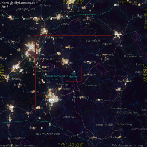
Analysis of Horn night lights 2016
Square area 10x10 km:
 0%
0%90-99
0%80-89
1.01%70-79
0%60-69
0%50-59
0%40-49
0%30-39
0.13%20-29
0.38%10-19
0.63%0-9
97.85%Square area 50x50 km:
0.52%90-99
0.82%80-89
0.67%70-79
0.58%60-69
0.75%50-59
0.66%40-49
0.77%30-39
0.57%20-29
1.24%10-19
4.12%0-9
89.29%Clear (daylight) street map image can be seen on geolist.org.
Map coordinates:
52° 18' 12.8" North, 8° 14' 31.1" East
51° 52' 17.4" North, 8° 56' 42.4" East
51° 26' 7" North, 9° 38' 53.6" East
Some cities around Horn sort by population:
• Detmold
8.9 km =5.5 mi,  326°
326°
• Blomberg
12.8 km =8 mi,  51°
51°
• Bad Lippspringe
13.2 km =8.2 mi,  221°
221°
• Steinheim
10 km =6.2 mi,  90°
90°
• Augustdorf
15.2 km =9.4 mi,  286°
286°
• Altenbeken
11.9 km =7.4 mi,  181°
181°
• Schlangen
9.7 km =6 mi, 224°
• Nieheim
13.7 km =8.5 mi,  122°
122°
2898924 (p: 7,018)
Sources (retrieved 2019-11-25):
» Earth at Night: Flat Maps 2012, 2016