Anröchte night lights from space
Night Light of Anröchte (North Rhine-Westphalia) from space (Germany) Src. Average luminocity for 10x10km area is 4.3757% and for 50x50km: 3.4318%.
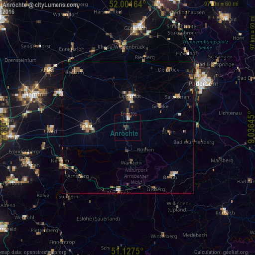
Analysis of Anröchte night lights 2016
Square area 10x10 km:
 0.4%
0.4%90-99
1.2%80-89
0%70-79
0.13%60-69
1.07%50-59
0.13%40-49
0.8%30-39
1.6%20-29
0.53%10-19
0%0-9
94.12%Square area 50x50 km:
0.27%90-99
0.32%80-89
0.32%70-79
0.42%60-69
0.6%50-59
0.61%40-49
0.77%30-39
0.46%20-29
0.4%10-19
1.4%0-9
94.43%Clear (daylight) street map image can be seen on geolist.org.
Map coordinates:
52° 0' 5.9" North, 7° 37' 48.7" East
51° 34' 0" North, 8° 19' 60" East
51° 7' 39" North, 9° 2' 11.2" East
Some cities around Anröchte sort by population:
• Lippstadt
11.9 km =7.4 mi,  3°
3°
• Warstein
13.6 km =8.5 mi,  175°
175°
• Büren
15.7 km =9.8 mi,  96°
96°
• Geseke
14.8 km =9.2 mi,  56°
56°
• Erwitte
5.1 km =3.2 mi, 3°
• Bad Sassendorf
11.7 km =7.3 mi,  279°
279°
• Möhnesee
15.7 km =9.8 mi,  241°
241°
• Rüthen
11 km =6.8 mi,  139°
139°
2955940 (p: 10,847)
Sources (retrieved 2019-11-25):
» Earth at Night: Flat Maps 2012, 2016