Möhnesee night lights from space
Night Light of Möhnesee (North Rhine-Westphalia) from space (Germany) Src. Average luminocity for 10x10km area is 1.5241% and for 50x50km: 5.7966%.
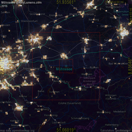
Analysis of Möhnesee night lights 2016
Square area 10x10 km:
 0%
0%90-99
0%80-89
0%70-79
0%60-69
0%50-59
0%40-49
0%30-39
0%20-29
0%10-19
2.01%0-9
97.99%Square area 50x50 km:
0.6%90-99
0.71%80-89
0.42%70-79
0.51%60-69
1.1%50-59
0.97%40-49
1.22%30-39
1%20-29
0.98%10-19
3.23%0-9
89.27%Clear (daylight) street map image can be seen on geolist.org.
Map coordinates:
51° 56' 8.2" North, 7° 25' 48.8" East
51° 30' 0" North, 8° 7' 60" East
51° 3' 36.7" North, 8° 50' 11.3" East
Some cities around Möhnesee sort by population:
• Arnsberg
13.4 km =8.3 mi,  194°
194°
• Soest
8.6 km =5.3 mi,  347°
347°
• Werl
16.4 km =10.2 mi,  291°
291°
• Warstein
16.1 km =10 mi,  112°
112°
• Welver
17.3 km =10.7 mi,  318°
318°
• Wickede
18.5 km =11.5 mi,  268°
268°
• Bad Sassendorf
9.5 km =5.9 mi,  13°
13°
• Anröchte
15.7 km =9.8 mi,  61°
61°
3207377 (p: 11,559)
Sources (retrieved 2019-11-25):
» Earth at Night: Flat Maps 2012, 2016