Rüthen night lights from space
Night Light of Rüthen (North Rhine-Westphalia) from space (Germany) Src. Average luminocity for 10x10km area is 0.2259% and for 50x50km: 3.2586%.
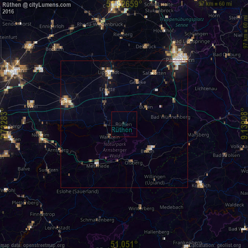
Analysis of Rüthen night lights 2016
Square area 10x10 km:
 0%
0%90-99
0%80-89
0%70-79
0%60-69
0%50-59
0%40-49
0%30-39
0.27%20-29
0.27%10-19
0%0-9
99.47%Square area 50x50 km:
0.39%90-99
0.45%80-89
0.22%70-79
0.4%60-69
0.49%50-59
0.54%40-49
0.55%30-39
0.46%20-29
0.56%10-19
1.69%0-9
94.23%Clear (daylight) street map image can be seen on geolist.org.
Map coordinates:
51° 55' 35.7" North, 7° 43' 58.2" East
51° 29' 27.2" North, 8° 26' 9.5" East
51° 3' 3.6" North, 9° 8' 20.7" East
Some cities around Rüthen sort by population:
• Warstein
7.9 km =4.9 mi,  229°
229°
• Brilon
14.2 km =8.8 mi,  138°
138°
• Büren
10.9 km =6.8 mi,  51°
51°
• Geseke
17.5 km =10.9 mi,  17°
17°
• Erwitte
15.1 km =9.4 mi,  333°
333°
• Olsberg
15.4 km =9.6 mi,  166°
166°
• Bestwig
14.7 km =9.1 mi,  189°
189°
• Anröchte
11 km =6.8 mi,  319°
319°
2842816 (p: 11,299)
Sources (retrieved 2019-11-25):
» Earth at Night: Flat Maps 2012, 2016