Alzey night lights from space
Night Light of Alzey (Rheinland-Pfalz) from space (Germany) Src. Average luminocity for 10x10km area is 5.5321% and for 50x50km: 9.9837%.
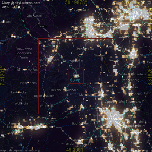
Analysis of Alzey night lights 2016
Square area 10x10 km:
 0.67%
0.67%90-99
0.94%80-89
1.07%70-79
1.07%60-69
0.53%50-59
0%40-49
0.53%30-39
0.53%20-29
0.53%10-19
1.07%0-9
93.05%Square area 50x50 km:
1.31%90-99
1.57%80-89
0.89%70-79
0.85%60-69
0.98%50-59
1.17%40-49
1.37%30-39
1.31%20-29
3.6%10-19
9.39%0-9
77.56%Clear (daylight) street map image can be seen on geolist.org.
Map coordinates:
50° 11' 55.6" North, 7° 24' 43.2" East
49° 44' 47.7" North, 8° 6' 54.5" East
49° 17' 24.4" North, 8° 49' 5.7" East
Some cities around Alzey sort by population:
• Bad Kreuznach
20.7 km =12.9 mi,  300°
300°
• Grünstadt
20.7 km =12.9 mi,  170°
170°
• Osthofen
15.8 km =9.8 mi,  107°
107°
• Nieder-Olm
19.5 km =12.1 mi,  19°
19°
• Kirchheimbolanden
11.8 km =7.3 mi,  217°
217°
• Wörrstadt
11.4 km =7.1 mi,  3°
3°
• Ober-Saulheim
13.1 km =8.1 mi,  6°
6°
• Heidesheim
19.1 km =11.9 mi,  162°
162°
2956710 (p: 18,241)
Sources (retrieved 2019-11-25):
» Earth at Night: Flat Maps 2012, 2016