Wörrstadt night lights from space
Night Light of Wörrstadt (Rheinland-Pfalz) from space (Germany) Src. Average luminocity for 10x10km area is 3.9305% and for 50x50km: 14.5611%.
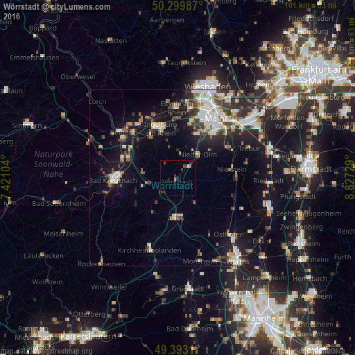
Analysis of Wörrstadt night lights 2016
Square area 10x10 km:
 0.27%
0.27%90-99
0.27%80-89
0%70-79
0.53%60-69
0%50-59
1.07%40-49
1.34%30-39
0.8%20-29
3.07%10-19
0.67%0-9
91.98%Square area 50x50 km:
2.65%90-99
2.9%80-89
1.23%70-79
1.26%60-69
1.38%50-59
1.55%40-49
2.06%30-39
2.27%20-29
4.39%10-19
10.25%0-9
70.06%Clear (daylight) street map image can be seen on geolist.org.
Map coordinates:
50° 17' 59.5" North, 7° 25' 15.7" East
49° 50' 55" North, 8° 7' 27" East
49° 23' 35.2" North, 8° 49' 38.2" East
Some cities around Wörrstadt sort by population:
• Ingelheim am Rhein
14.4 km =8.9 mi,  340°
340°
• Nieder-Ingelheim
14.8 km =9.2 mi,  345°
345°
• Alzey
11.4 km =7.1 mi,  183°
183°
• Nieder-Olm
9.1 km =5.7 mi,  39°
39°
• Nierstein
15.4 km =9.6 mi,  81°
81°
• Ober-Saulheim
1.9 km =1.2 mi,  25°
25°
• Oppenheim
16.9 km =10.5 mi,  87°
87°
• Gau-Algesheim
14.3 km =8.9 mi,  327°
327°
2806105 (p: 7,668)
Sources (retrieved 2019-11-25):
» Earth at Night: Flat Maps 2012, 2016