Ober-Saulheim night lights from space
Night Light of Ober-Saulheim (Rheinland-Pfalz) from space (Germany) Src. Average luminocity for 10x10km area is 4.75% and for 50x50km: 15.5209%.
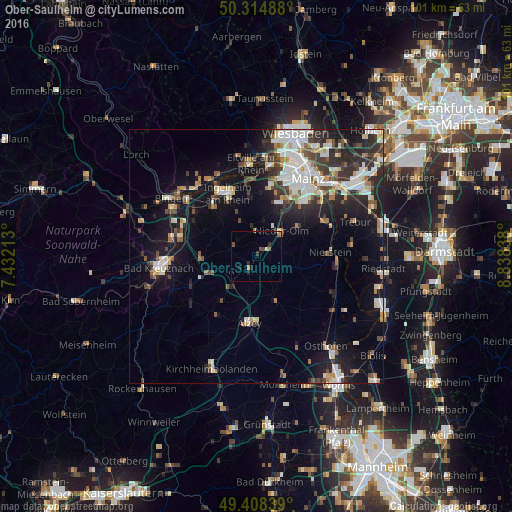
Analysis of Ober-Saulheim night lights 2016
Square area 10x10 km:
 0.27%
0.27%90-99
0.27%80-89
0.27%70-79
0.67%60-69
0.53%50-59
0.94%40-49
1.47%30-39
0.8%20-29
2.27%10-19
0.67%0-9
91.84%Square area 50x50 km:
2.98%90-99
3.21%80-89
1.28%70-79
1.36%60-69
1.46%50-59
1.51%40-49
2.03%30-39
2.41%20-29
4.68%10-19
10.78%0-9
68.3%Clear (daylight) street map image can be seen on geolist.org.
Map coordinates:
50° 18' 53.6" North, 7° 25' 55.7" East
49° 51' 49.5" North, 8° 8' 6.9" East
49° 24' 30.2" North, 8° 50' 18.2" East
Some cities around Ober-Saulheim sort by population:
• Ingelheim am Rhein
13.1 km =8.1 mi,  335°
335°
• Nieder-Ingelheim
13.4 km =8.3 mi, 340°
• Alzey
13.1 km =8.1 mi,  186°
186°
• Nieder-Olm
7.3 km =4.5 mi,  43°
43°
• Nierstein
14.4 km =8.9 mi,  87°
87°
• Wörrstadt
1.9 km =1.2 mi,  205°
205°
• Bodenheim
15.4 km =9.6 mi,  58°
58°
• Gau-Algesheim
13.4 km =8.3 mi,  320°
320°
2859199 (p: 7,325)
Sources (retrieved 2019-11-25):
» Earth at Night: Flat Maps 2012, 2016