Kirchheimbolanden night lights from space
Night Light of Kirchheimbolanden (Rheinland-Pfalz) from space (Germany) Src. Average luminocity for 10x10km area is 4.2313% and for 50x50km: 7.1203%.
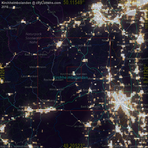
Analysis of Kirchheimbolanden night lights 2016
Square area 10x10 km:
 0.53%
0.53%90-99
0.94%80-89
0.67%70-79
0%60-69
0.53%50-59
0.4%40-49
0.67%30-39
0%20-29
1.87%10-19
0.27%0-9
94.12%Square area 50x50 km:
0.86%90-99
1.23%80-89
0.72%70-79
0.55%60-69
0.8%50-59
0.83%40-49
1.14%30-39
0.91%20-29
1.89%10-19
5.59%0-9
85.47%Clear (daylight) street map image can be seen on geolist.org.
Map coordinates:
50° 6' 55.8" North, 7° 18' 43.2" East
49° 39' 45" North, 8° 0' 54.5" East
49° 12' 18.8" North, 8° 43' 5.7" East
Some cities around Kirchheimbolanden sort by population:
• Alzey
11.8 km =7.3 mi,  37°
37°
• Grünstadt
15.3 km =9.5 mi,  136°
136°
• Herxheim am Berg
20.7 km =12.9 mi,  145°
145°
• Eisenberg
12.3 km =7.6 mi,  160°
160°
• Wörrstadt
22.1 km =13.7 mi,  20°
20°
• Enkenbach-Alsenborn
21.6 km =13.4 mi,  202°
202°
• Heidesheim
15.7 km =9.8 mi,  124°
124°
• Rockenhausen
14.4 km =8.9 mi,  255°
255°
2890478 (p: 8,006)
Sources (retrieved 2019-11-25):
» Earth at Night: Flat Maps 2012, 2016