Heidesheim night lights from space
Night Light of Heidesheim (Rheinland-Pfalz) from space (Germany) Src. Average luminocity for 10x10km area is 10.6891% and for 50x50km: 14.9939%.
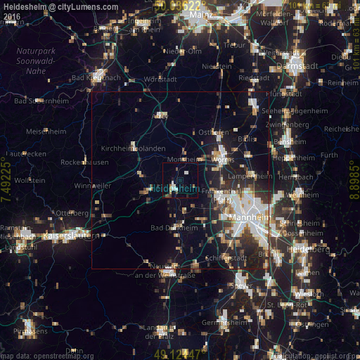
Analysis of Heidesheim night lights 2016
Square area 10x10 km:
 2.1%
2.1%90-99
2.38%80-89
0.56%70-79
0.28%60-69
1.12%50-59
0.84%40-49
1.68%30-39
0.56%20-29
0.98%10-19
2.52%0-9
86.97%Square area 50x50 km:
3.03%90-99
3.3%80-89
1.29%70-79
1.12%60-69
1.56%50-59
1.43%40-49
1.75%30-39
2.11%20-29
3.97%10-19
8.96%0-9
71.48%Clear (daylight) street map image can be seen on geolist.org.
Map coordinates:
50° 2' 10.4" North, 7° 29' 32.1" East
49° 34' 56.9" North, 8° 11' 43.3" East
49° 7' 28.1" North, 8° 53' 54.6" East
Some cities around Heidesheim sort by population:
• Worms
13.1 km =8.1 mi,  64°
64°
• Frankenthal
12.6 km =7.8 mi,  115°
115°
• Grünstadt
3.2 km =2 mi,  227°
227°
• Herxheim am Berg
8.2 km =5.1 mi,  188°
188°
• Bobenheim-Roxheim
11.7 km =7.3 mi,  87°
87°
• Eisenberg
9.3 km =5.8 mi,  253°
253°
• Maxdorf
12.6 km =7.8 mi,  146°
146°
• Lambsheim
10.2 km =6.3 mi,  138°
138°
2907790 (p: 6,976)
Sources (retrieved 2019-11-25):
» Earth at Night: Flat Maps 2012, 2016