Odry night lights from space
Night Light of Odry (Moravskoslezský) from space (Czech Republic) Src. Average luminocity for 10x10km area is 2.5388% and for 50x50km: 4.2489%.
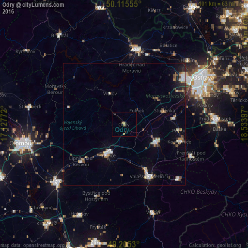
Analysis of Odry night lights 2016
Square area 10x10 km:
 0%
0%90-99
0%80-89
0.13%70-79
1.07%60-69
0.8%50-59
0.13%40-49
0%30-39
1.34%20-29
0.8%10-19
0%0-9
95.72%Square area 50x50 km:
0.51%90-99
0.81%80-89
0.32%70-79
0.26%60-69
0.54%50-59
0.71%40-49
0.62%30-39
0.52%20-29
0.64%10-19
1.96%0-9
93.12%Clear (daylight) street map image can be seen on geolist.org.
Map coordinates:
50° 6' 56" North, 17° 7' 39.8" East
49° 39' 45.2" North, 17° 49' 51" East
49° 12' 19.1" North, 18° 32' 2.3" East
Some cities around Odry sort by population:
• Nový Jičín
15 km =9.3 mi,  120°
120°
• Hranice
14.5 km =9 mi,  208°
208°
• Studénka
19.1 km =11.9 mi,  69°
69°
• Příbor
22.7 km =14.1 mi,  96°
96°
• Lipník nad Bečvou
23.2 km =14.4 mi,  229°
229°
• Bílovec
16.9 km =10.5 mi,  51°
51°
• Vítkov
13.8 km =8.6 mi,  334°
334°
• Fulnek
7.6 km =4.7 mi,  43°
43°
3069136 (p: 7,395)
Sources (retrieved 2019-11-25):
» Earth at Night: Flat Maps 2012, 2016