Hranice night lights from space
Night Light of Hranice (Olomoucký) from space (Czech Republic) Src. Average luminocity for 10x10km area is 13.8305% and for 50x50km: 4.1202%.
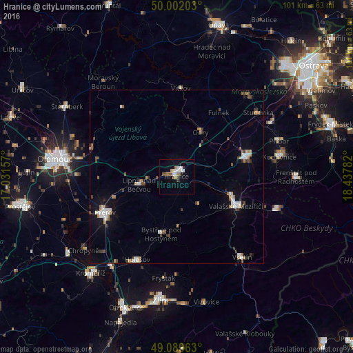
Analysis of Hranice night lights 2016
Square area 10x10 km:
 2.8%
2.8%90-99
3.08%80-89
0.28%70-79
1.12%60-69
1.54%50-59
1.82%40-49
2.38%30-39
0.84%20-29
0.28%10-19
5.18%0-9
80.67%Square area 50x50 km:
0.62%90-99
0.79%80-89
0.27%70-79
0.33%60-69
0.49%50-59
0.47%40-49
0.59%30-39
0.53%20-29
0.33%10-19
1.98%0-9
93.59%Clear (daylight) street map image can be seen on geolist.org.
Map coordinates:
50° 0' 7.3" North, 17° 1' 53.7" East
49° 32' 52.7" North, 17° 44' 4.9" East
49° 5' 22.7" North, 18° 26' 16.2" East
Some cities around Hranice sort by population:
• Přerov
22.9 km =14.2 mi,  243°
243°
• Valašské Meziříčí
19.1 km =11.9 mi,  116°
116°
• Nový Jičín
20.5 km =12.7 mi,  75°
75°
• Bystřice pod Hostýnem
17.1 km =10.6 mi,  194°
194°
• Lipník nad Bečvou
11 km =6.8 mi,  257°
257°
• Odry
14.5 km =9 mi,  28°
28°
• Vítkov
25.2 km =15.7 mi,  2°
2°
• Fulnek
21.9 km =13.6 mi, 33°
3074893 (p: 19,582)
Sources (retrieved 2019-11-25):
» Earth at Night: Flat Maps 2012, 2016