Vítkov night lights from space
Night Light of Vítkov (Moravskoslezský) from space (Czech Republic) Src. Average luminocity for 10x10km area is 0.8436% and for 50x50km: 2.6772%.
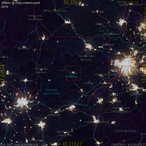
Analysis of Vítkov night lights 2016
Square area 10x10 km:
 0%
0%90-99
0.53%80-89
0%70-79
0%60-69
0%50-59
0.53%40-49
0%30-39
0%20-29
0%10-19
0%0-9
98.93%Square area 50x50 km:
0.32%90-99
0.55%80-89
0.13%70-79
0.2%60-69
0.41%50-59
0.44%40-49
0.36%30-39
0.36%20-29
0.33%10-19
1.07%0-9
95.82%Clear (daylight) street map image can be seen on geolist.org.
Map coordinates:
50° 13' 35" North, 17° 2' 46.6" East
49° 46' 28" North, 17° 44' 57.9" East
49° 19' 5.7" North, 18° 27' 9.1" East
Some cities around Vítkov sort by population:
• Opava
21.3 km =13.2 mi,  31°
31°
• Hranice
25.2 km =15.7 mi,  182°
182°
• Studénka
24.3 km =15.1 mi,  103°
103°
• Bílovec
19.2 km =11.9 mi, 95°
• Odry
13.8 km =8.6 mi,  154°
154°
• Kravaře
25.3 km =15.7 mi,  46°
46°
• Fulnek
13 km =8.1 mi,  121°
121°
• Hradec nad Moravici
14.1 km =8.8 mi,  40°
40°
3062811 (p: 6,202)
Sources (retrieved 2019-11-25):
» Earth at Night: Flat Maps 2012, 2016