Studénka night lights from space
Night Light of Studénka (Moravskoslezský) from space (Czech Republic) Src. Average luminocity for 10x10km area is 6.8703% and for 50x50km: 12.715%.
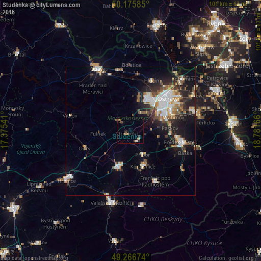
Analysis of Studénka night lights 2016
Square area 10x10 km:
 0%
0%90-99
1.07%80-89
0.53%70-79
0.4%60-69
1.34%50-59
2.54%40-49
1.2%30-39
1.6%20-29
0.8%10-19
1.74%0-9
88.77%Square area 50x50 km:
2.32%90-99
2.49%80-89
1.01%70-79
1.21%60-69
1.47%50-59
1.61%40-49
1.6%30-39
1.76%20-29
3.67%10-19
7.42%0-9
75.44%Clear (daylight) street map image can be seen on geolist.org.
Map coordinates:
50° 10' 33.1" North, 17° 22' 31.5" East
49° 43' 24.3" North, 18° 4' 42.7" East
49° 16' 0.3" North, 18° 46' 54" East
Some cities around Studénka sort by population:
• Ostrava
19.1 km =11.9 mi,  49°
49°
• Nový Jičín
15.2 km =9.4 mi,  198°
198°
• Kopřivnice
14.6 km =9.1 mi,  160°
160°
• Příbor
10.3 km =6.4 mi,  152°
152°
• Bílovec
5.8 km =3.6 mi,  309°
309°
• Odry
19.1 km =11.9 mi,  249°
249°
• Vratimov
17.4 km =10.8 mi,  72°
72°
• Fulnek
12.7 km =7.9 mi,  264°
264°
3064807 (p: 10,341)
Sources (retrieved 2019-11-25):
» Earth at Night: Flat Maps 2012, 2016