Příbor night lights from space
Night Light of Příbor (Moravskoslezský) from space (Czech Republic) Src. Average luminocity for 10x10km area is 11.1975% and for 50x50km: 11.6835%.
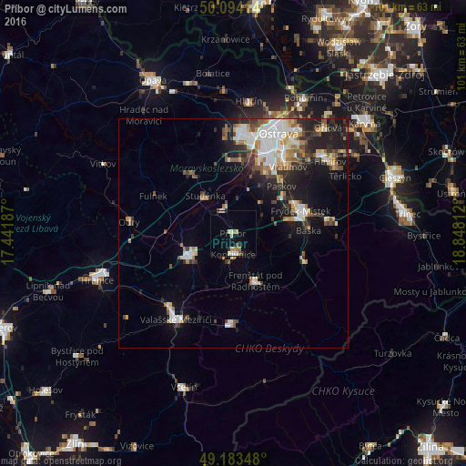
Analysis of Příbor night lights 2016
Square area 10x10 km:
 1.4%
1.4%90-99
2.1%80-89
1.4%70-79
0.98%60-69
1.96%50-59
1.4%40-49
0.14%30-39
1.54%20-29
0.28%10-19
2.38%0-9
86.41%Square area 50x50 km:
2.24%90-99
2.24%80-89
1.03%70-79
1.1%60-69
1.34%50-59
1.54%40-49
1.46%30-39
1.67%20-29
3.01%10-19
6.52%0-9
77.85%Clear (daylight) street map image can be seen on geolist.org.
Map coordinates:
50° 5' 38.9" North, 17° 26' 30.7" East
49° 38' 27.4" North, 18° 8' 42" East
49° 11' 0.5" North, 18° 50' 53.2" East
Some cities around Příbor sort by population:
• Frýdek-Místek
15.5 km =9.6 mi,  72°
72°
• Nový Jičín
11 km =6.8 mi,  241°
241°
• Kopřivnice
4.6 km =2.9 mi,  180°
180°
• Frenštát pod Radhoštěm
11.3 km =7 mi,  155°
155°
• Studénka
10.3 km =6.4 mi,  332°
332°
• Frýdlant nad Ostravicí
16.4 km =10.2 mi,  109°
109°
• Bílovec
15.8 km =9.8 mi,  324°
324°
• Vratimov
18.6 km =11.6 mi,  39°
39°
3067544 (p: 8,789)
Sources (retrieved 2019-11-25):
» Earth at Night: Flat Maps 2012, 2016