Jablunkov night lights from space
Night Light of Jablunkov (Moravskoslezský) from space (Czech Republic) Src. Average luminocity for 10x10km area is 0.3992% and for 50x50km: 4.7501%.
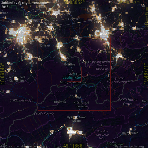
Analysis of Jablunkov night lights 2016
Square area 10x10 km:
 0%
0%90-99
0%80-89
0%70-79
0%60-69
0%50-59
0%40-49
0%30-39
0%20-29
1.12%10-19
0.56%0-9
98.32%Square area 50x50 km:
0.55%90-99
0.68%80-89
0.47%70-79
0.39%60-69
0.52%50-59
0.61%40-49
0.87%30-39
0.86%20-29
1.39%10-19
4.32%0-9
89.33%Clear (daylight) street map image can be seen on geolist.org.
Map coordinates:
50° 1' 49.9" North, 18° 3' 41.3" East
49° 34' 36.2" North, 18° 45' 52.5" East
49° 7' 7.2" North, 19° 28' 3.8" East
Some cities around Jablunkov sort by population:
• Třinec
13.1 km =8.1 mi,  328°
328°
• Cieszyn, PL
21.6 km =13.4 mi, 333°
• Český Těšín
21.3 km =13.2 mi, 332°
• Čadca, SK
15.9 km =9.9 mi,  173°
173°
• Ustroń, PL
16.3 km =10.1 mi,  9°
9°
• Wisła, PL
11.2 km =7 mi,  37°
37°
• Brenna, PL
19.3 km =12 mi,  30°
30°
• Bystřice
7.4 km =4.6 mi, 334°
3074593 (p: 5,782)
Sources (retrieved 2019-11-25):
» Earth at Night: Flat Maps 2012, 2016