Brenna night lights from space
Night Light of Brenna (Silesia) from space (Poland) Src. Average luminocity for 10x10km area is 1.2433% and for 50x50km: 11.9051%.
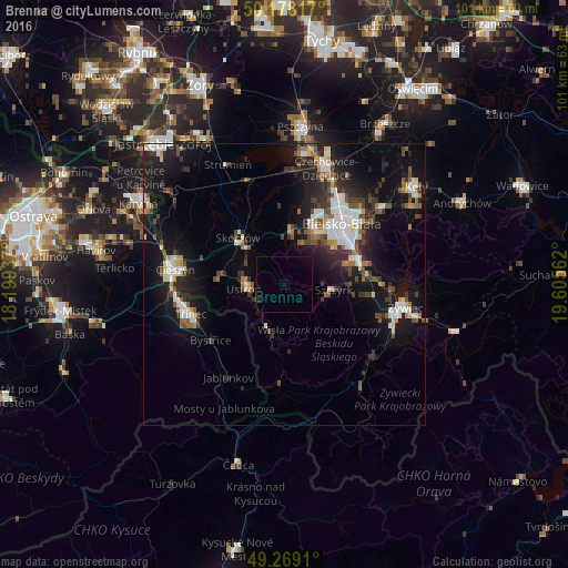
Analysis of Brenna night lights 2016
Square area 10x10 km:
 0%
0%90-99
0%80-89
0%70-79
0%60-69
0%50-59
0%40-49
0%30-39
0.27%20-29
0.53%10-19
0.4%0-9
98.8%Square area 50x50 km:
2.11%90-99
1.97%80-89
0.91%70-79
0.75%60-69
1.16%50-59
1.4%40-49
1.86%30-39
2.12%20-29
3.55%10-19
11%0-9
73.18%Clear (daylight) street map image can be seen on geolist.org.
Map coordinates:
50° 10' 41.4" North, 18° 11' 57.7" East
49° 43' 32.7" North, 18° 54' 9" East
49° 16' 8.8" North, 19° 36' 20.2" East
Some cities around Brenna sort by population:
• Bielsko-Biala
14.9 km =9.3 mi,  43°
43°
• Ustroń
7.2 km =4.5 mi,  266°
266°
• Skoczów
11.7 km =7.3 mi,  315°
315°
• Wisła
8.3 km =5.2 mi,  202°
202°
• Jaworze
8.2 km =5.1 mi,  23°
23°
• Wilkowice
14.1 km =8.8 mi,  72°
72°
• Szczyrk
9.3 km =5.8 mi,  95°
95°
• Bystřice, CZ
16.4 km =10.2 mi,  232°
232°
3102652 (p: 5,859)
Sources (retrieved 2019-11-25):
» Earth at Night: Flat Maps 2012, 2016