Ustroń night lights from space
Night Light of Ustroń (Silesia) from space (Poland) Src. Average luminocity for 10x10km area is 8.7246% and for 50x50km: 11.5252%.
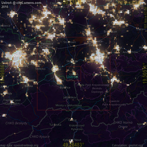
Analysis of Ustroń night lights 2016
Square area 10x10 km:
 0.4%
0.4%90-99
0.13%80-89
1.2%70-79
0.94%60-69
1.74%50-59
0.94%40-49
2.14%30-39
2.81%20-29
2.01%10-19
1.2%0-9
86.5%Square area 50x50 km:
1.95%90-99
1.77%80-89
0.79%70-79
0.81%60-69
1.24%50-59
1.33%40-49
1.79%30-39
2.23%20-29
3.74%10-19
11.96%0-9
72.39%Clear (daylight) street map image can be seen on geolist.org.
Map coordinates:
50° 10' 26.3" North, 18° 5' 55.9" East
49° 43' 17.5" North, 18° 48' 7.1" East
49° 15' 53.4" North, 19° 30' 18.4" East
Some cities around Ustroń sort by population:
• Třinec, CZ
10.6 km =6.6 mi,  242°
242°
• Cieszyn
12.6 km =7.8 mi,  285°
285°
• Český Těšín, CZ
12.9 km =8 mi,  282°
282°
• Skoczów
8.9 km =5.5 mi,  353°
353°
• Wisła
8.3 km =5.2 mi,  150°
150°
• Jaworze
13.2 km =8.2 mi,  52°
52°
• Brenna
7.2 km =4.5 mi,  86°
86°
• Bystřice, CZ
11.1 km =6.9 mi,  211°
211°
3082751 (p: 15,637)
Sources (retrieved 2019-11-25):
» Earth at Night: Flat Maps 2012, 2016