Tres Ríos night lights from space
Night Light of Tres Ríos (Cartago) from space (Costa Rica) Src. Average luminocity for 10x10km area is 65.5599% and for 50x50km: 25.8163%.
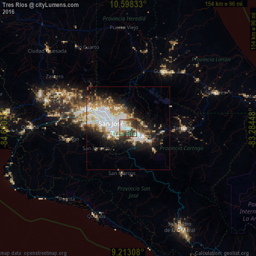
Analysis of Tres Ríos night lights 2016
Square area 10x10 km:
 15.7%
15.7%90-99
18.39%80-89
6.2%70-79
5.17%60-69
7.44%50-59
8.68%40-49
7.44%30-39
26.65%20-29
4.34%10-19
0%0-9
0%Square area 50x50 km:
7.45%90-99
5.66%80-89
2.28%70-79
2.24%60-69
3.27%50-59
2.8%40-49
3.17%30-39
3.44%20-29
4.94%10-19
8.36%0-9
56.38%Clear (daylight) street map image can be seen on geolist.org.
Map coordinates:
10° 35' 54" North, 84° 41' 26.6" West
9° 54' 23.2" North, 83° 59' 15.4" West
9° 12' 47.1" North, 83° 17' 4.1" West
Some cities around Tres Ríos sort by population:
• Curridabat
5.1 km =3.2 mi,  276°
276°
• San Pedro
7.3 km =4.5 mi,  289°
289°
• Ipís
7.3 km =4.5 mi,  337°
337°
• Patarrá
5.9 km =3.7 mi,  241°
241°
• San Diego
1.9 km =1.2 mi, 243°
• Concepción
3.3 km =2.1 mi, 335°
• Sabanilla
7.1 km =4.4 mi,  307°
307°
• Granadilla
4.5 km =2.8 mi, 314°
3621224 (p: 10,430)
Sources (retrieved 2019-11-25):
» Earth at Night: Flat Maps 2012, 2016