Granadilla night lights from space
Night Light of Granadilla (San José) from space (Costa Rica) Src. Average luminocity for 10x10km area is 89.8905% and for 50x50km: 27.6399%.
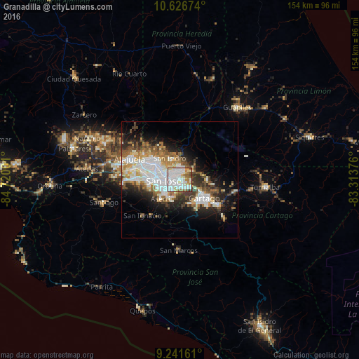
Analysis of Granadilla night lights 2016
Square area 10x10 km:
 42.98%
90-99
27.89%80-89
6.4%70-79
7.23%60-69
8.47%50-59
3.1%40-49
2.27%30-39
1.65%20-29
0%10-19
0%0-9
0%Square area 50x50 km:
7.73%90-99
5.95%80-89
2.58%70-79
2.47%60-69
3.57%50-59
3.27%40-49
3.39%30-39
3.8%20-29
5.4%10-19
8.86%0-9
53%Clear (daylight) street map image can be seen on geolist.org.
Map coordinates:
10° 37' 36.3" North, 84° 43' 12" West
9° 56' 5.7" North, 84° 1' 0.8" West
9° 14' 29.8" North, 83° 18' 49.5" West
Some cities around Granadilla sort by population:
• Curridabat
3.2 km =2 mi,  216°
216°
• San Vicente
4.4 km =2.7 mi,  309°
309°
• Purral
3 km =1.9 mi,  329°
329°
• San Pedro
3.8 km =2.4 mi,  258°
258°
• Ipís
3.6 km =2.2 mi,  6°
6°
• San Diego
4.3 km =2.7 mi,  158°
158°
• Concepción
1.9 km =1.2 mi,  95°
95°
• Sabanilla
2.7 km =1.7 mi,  295°
295°
3623643 (p: 12,683)
Sources (retrieved 2019-11-25):
» Earth at Night: Flat Maps 2012, 2016