Patarrá night lights from space
Night Light of Patarrá (San José) from space (Costa Rica) Src. Average luminocity for 10x10km area is 69.2603% and for 50x50km: 28.2416%.

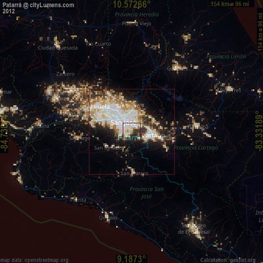
Analysis of Patarrá night lights 2016
Square area 10x10 km:
 25%
25%90-99
19.21%80-89
3.93%70-79
3.51%60-69
11.16%50-59
5.37%40-49
5.58%30-39
10.74%20-29
13.02%10-19
2.48%0-9
0%Square area 50x50 km:
7.84%90-99
6%80-89
2.58%70-79
2.61%60-69
3.86%50-59
3.44%40-49
3.54%30-39
3.93%20-29
5.52%10-19
8.96%0-9
51.71%Clear (daylight) street map image can be seen on geolist.org.
Map coordinates:
10° 34' 21.6" North, 84° 44' 17.3" West
9° 52' 50.6" North, 84° 2' 6" West
9° 11' 14.3" North, 83° 19' 54.8" West
Some cities around Patarrá sort by population:
• Curridabat
3.5 km =2.2 mi,  1°
1°
• San Miguel
3 km =1.9 mi,  249°
249°
• San Pedro
5.6 km =3.5 mi,  341°
341°
• San Diego
4.1 km =2.5 mi,  60°
60°
• San Juan de Dios
5.5 km =3.4 mi,  266°
266°
• San Rafael Arriba
4.6 km =2.9 mi,  262°
262°
• Granadilla
6.3 km =3.9 mi,  18°
18°
• Tres Ríos
5.9 km =3.7 mi, 61°
3622507 (p: 23,983)
Sources (retrieved 2019-11-25):
» Earth at Night: Flat Maps 2012, 2016