Villanueva night lights from space
Night Light of Villanueva (Bolívar) from space (Colombia) Src. Average luminocity for 10x10km area is 4.3595% and for 50x50km: 10.0139%.
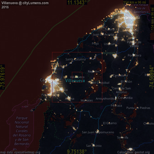
Analysis of Villanueva night lights 2016
Square area 10x10 km:
 0%
0%90-99
0%80-89
0.83%70-79
1.24%60-69
2.89%50-59
0%40-49
0%30-39
0%20-29
0.83%10-19
0.83%0-9
93.39%Square area 50x50 km:
1.39%90-99
1.17%80-89
0.74%70-79
1.84%60-69
2.14%50-59
0.81%40-49
1.76%30-39
2.3%20-29
2%10-19
5.19%0-9
80.66%Clear (daylight) street map image can be seen on geolist.org.
Map coordinates:
11° 8' 3.5" North, 75° 58' 34.3" West
10° 26' 37" North, 75° 16' 23" West
9° 45' 5" North, 74° 34' 11.8" West
Some cities around Villanueva sort by population:
• Turbaco
19.7 km =12.2 mi,  229°
229°
• Arjona
22.4 km =13.9 mi,  200°
200°
• Repelón
17.2 km =10.7 mi,  70°
70°
• San Estanislao
14.3 km =8.9 mi,  110°
110°
• Santa Rosa
10.6 km =6.6 mi,  270°
270°
• Clemencia
14.8 km =9.2 mi,  337°
337°
• Soplaviento
15.5 km =9.6 mi, 111°
• Santa Catalina
17.9 km =11.1 mi,  354°
354°
3665935 (p: 12,791)
Sources (retrieved 2019-11-25):
» Earth at Night: Flat Maps 2012, 2016