Santa Catalina night lights from space
Night Light of Santa Catalina (Bolívar) from space (Colombia) Src. Average luminocity for 10x10km area is 3.8574% and for 50x50km: 6.356%.
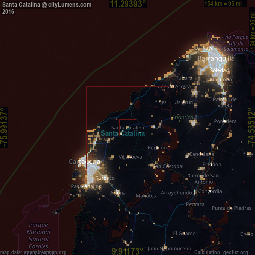
Analysis of Santa Catalina night lights 2016
Square area 10x10 km:
 0%
0%90-99
0%80-89
0.83%70-79
0.83%60-69
2.07%50-59
0.83%40-49
0.83%30-39
0%20-29
0%10-19
0%0-9
94.63%Square area 50x50 km:
0.95%90-99
0.75%80-89
0.49%70-79
1.33%60-69
1.16%50-59
0.42%40-49
0.72%30-39
1.36%20-29
1.38%10-19
4.06%0-9
87.37%Clear (daylight) street map image can be seen on geolist.org.
Map coordinates:
11° 17' 38.1" North, 75° 59' 28.9" West
10° 36' 13" North, 75° 17' 17.7" West
9° 54' 42.2" North, 74° 35' 6.4" West
Some cities around Santa Catalina sort by population:
• Cartagena
33.5 km =20.8 mi,  227°
227°
• Turbaco
33.3 km =20.7 mi,  203°
203°
• Repelón
21.6 km =13.4 mi,  123°
123°
• Luruaco
15 km =9.3 mi,  84°
84°
• Villanueva
17.9 km =11.1 mi,  174°
174°
• San Estanislao
27.3 km =17 mi,  146°
146°
• Clemencia
5.8 km =3.6 mi,  224°
224°
• Soplaviento
28.4 km =17.6 mi, 145°
3668861 (p: 6,084)
Sources (retrieved 2019-11-25):
» Earth at Night: Flat Maps 2012, 2016