Clemencia night lights from space
Night Light of Clemencia (Bolívar) from space (Colombia) Src. Average luminocity for 10x10km area is 5.6012% and for 50x50km: 9.2938%.
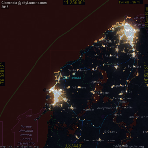
Analysis of Clemencia night lights 2016
Square area 10x10 km:
 0%
0%90-99
0%80-89
0.83%70-79
1.65%60-69
2.48%50-59
0.83%40-49
0.83%30-39
0.83%20-29
0%10-19
0.83%0-9
91.74%Square area 50x50 km:
1.78%90-99
1.45%80-89
0.68%70-79
1.56%60-69
1.64%50-59
0.56%40-49
1.09%30-39
1.91%20-29
2.06%10-19
4.81%0-9
82.44%Clear (daylight) street map image can be seen on geolist.org.
Map coordinates:
11° 15' 24.7" North, 76° 1' 41.2" West
10° 33' 59.2" North, 75° 19' 30" West
9° 52' 28.2" North, 74° 37' 18.7" West
Some cities around Clemencia sort by population:
• Cartagena
27.8 km =17.3 mi,  228°
228°
• Repelón
23.3 km =14.5 mi,  109°
109°
• Luruaco
19.8 km =12.3 mi,  73°
73°
• Villanueva
14.8 km =9.2 mi,  157°
157°
• San Estanislao
26.7 km =16.6 mi,  134°
134°
• Santa Rosa
14.4 km =8.9 mi,  199°
199°
• Soplaviento
27.9 km =17.3 mi, 133°
• Santa Catalina
5.8 km =3.6 mi,  44°
44°
3686196 (p: 8,775)
Sources (retrieved 2019-11-25):
» Earth at Night: Flat Maps 2012, 2016