Repelón night lights from space
Night Light of Repelón (Atlántico) from space (Colombia) Src. Average luminocity for 10x10km area is 3.7603% and for 50x50km: 2.827%.
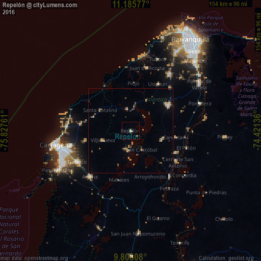
Analysis of Repelón night lights 2016
Square area 10x10 km:
 0.62%
0.62%90-99
0.21%80-89
0%70-79
2.48%60-69
0%50-59
0%40-49
0%30-39
0.83%20-29
0%10-19
0.41%0-9
95.45%Square area 50x50 km:
0.14%90-99
0.24%80-89
0.23%70-79
0.59%60-69
0.69%50-59
0.25%40-49
0.36%30-39
0.73%20-29
0.56%10-19
0.35%0-9
95.87%Clear (daylight) street map image can be seen on geolist.org.
Map coordinates:
11° 11' 8.8" North, 75° 49' 39.4" West
10° 29' 42.7" North, 75° 7' 28.1" West
9° 48' 11.1" North, 74° 25' 16.9" West
Some cities around Repelón sort by population:
• Santa Lucía
26.2 km =16.3 mi,  136°
136°
• Manatí
18.9 km =11.7 mi,  106°
106°
• Luruaco
13.9 km =8.6 mi,  347°
347°
• Villanueva
17.2 km =10.7 mi,  250°
250°
• San Estanislao
11.2 km =7 mi,  195°
195°
• Clemencia
23.3 km =14.5 mi,  289°
289°
• Soplaviento
11.5 km =7.1 mi,  188°
188°
• Santa Catalina
21.6 km =13.4 mi,  303°
303°
3670874 (p: 18,685)
Sources (retrieved 2019-11-25):
» Earth at Night: Flat Maps 2012, 2016