Santa Rosa night lights from space
Night Light of Santa Rosa (Bolívar) from space (Colombia) Src. Average luminocity for 10x10km area is 7.3182% and for 50x50km: 13.5296%.
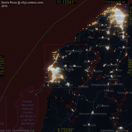
Analysis of Santa Rosa night lights 2016
Square area 10x10 km:
 0%
0%90-99
0%80-89
1.45%70-79
1.03%60-69
0.83%50-59
0.62%40-49
1.03%30-39
1.86%20-29
0.83%10-19
9.09%0-9
83.26%Square area 50x50 km:
2.37%90-99
2.05%80-89
0.94%70-79
1.93%60-69
2.33%50-59
1%40-49
2.11%30-39
2.9%20-29
3.23%10-19
8.32%0-9
72.79%Clear (daylight) street map image can be seen on geolist.org.
Map coordinates:
11° 8' 7.5" North, 76° 4' 22.3" West
10° 26' 41" North, 75° 22' 11" West
9° 45' 9" North, 74° 39' 59.8" West
Some cities around Santa Rosa sort by population:
• Cartagena
16.6 km =10.3 mi,  252°
252°
• Turbaco
13.6 km =8.5 mi,  199°
199°
• Arjona
21.3 km =13.2 mi,  172°
172°
• Villanueva
10.6 km =6.6 mi,  90°
90°
• San Estanislao
24.5 km =15.2 mi,  102°
102°
• Turbaná
20.8 km =12.9 mi, 202°
• Clemencia
14.4 km =8.9 mi,  19°
19°
• Soplaviento
25.7 km =16 mi, 102°
3668472 (p: 10,604)
Sources (retrieved 2019-11-25):
» Earth at Night: Flat Maps 2012, 2016