Soplaviento night lights from space
Night Light of Soplaviento (Bolívar) from space (Colombia) Src. Average luminocity for 10x10km area is 10.6054% and for 50x50km: 2.7479%.
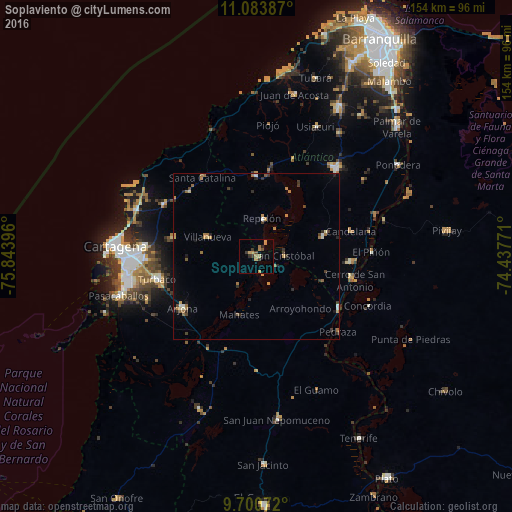
Analysis of Soplaviento night lights 2016
Square area 10x10 km:
 0%
0%90-99
0%80-89
1.65%70-79
3.31%60-69
3.31%50-59
0%40-49
1.86%30-39
3.31%20-29
1.45%10-19
0.83%0-9
84.3%Square area 50x50 km:
0.08%90-99
0.24%80-89
0.22%70-79
0.63%60-69
0.7%50-59
0.29%40-49
0.35%30-39
0.68%20-29
0.49%10-19
0.31%0-9
95.99%Clear (daylight) street map image can be seen on geolist.org.
Map coordinates:
11° 5' 1.9" North, 75° 50' 38.3" West
10° 23' 35" North, 75° 8' 27" West
9° 42' 2.6" North, 74° 26' 15.8" West
Some cities around Soplaviento sort by population:
• Repelón
11.5 km =7.1 mi,  8°
8°
• Santa Lucía
21.2 km =13.2 mi,  111°
111°
• Manatí
20.8 km =12.9 mi,  73°
73°
• Luruaco
24.9 km =15.5 mi,  357°
357°
• Villanueva
15.5 km =9.6 mi,  291°
291°
• San Estanislao
1.3 km =0.8 mi,  297°
297°
• Santa Rosa
25.7 km =16 mi,  282°
282°
• Mahates
18.6 km =11.6 mi,  196°
196°
3667811 (p: 8,067)
Sources (retrieved 2019-11-25):
» Earth at Night: Flat Maps 2012, 2016