Uribia night lights from space
Night Light of Uribia (La Guajira) from space (Colombia) Src. Average luminocity for 10x10km area is 5.2273% and for 50x50km: 0.4375%.
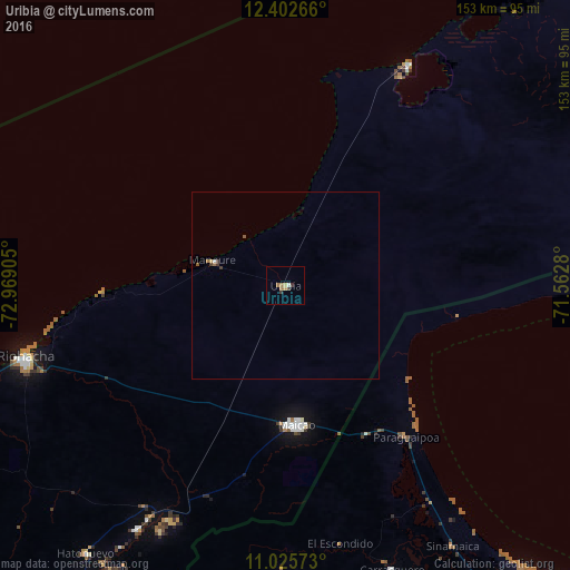
Analysis of Uribia night lights 2016
Square area 10x10 km:
 0.41%
0.41%90-99
0.41%80-89
0%70-79
1.65%60-69
1.65%50-59
0.83%40-49
0.62%30-39
1.45%20-29
0.41%10-19
0%0-9
92.56%Square area 50x50 km:
0.03%90-99
0.03%80-89
0.03%70-79
0.07%60-69
0.1%50-59
0.13%40-49
0.04%30-39
0.18%20-29
0.02%10-19
0%0-9
99.36%Clear (daylight) street map image can be seen on geolist.org.
Map coordinates:
12° 24' 9.6" North, 72° 58' 8.6" West
11° 42' 54.2" North, 72° 15' 57.3" West
11° 1' 32.6" North, 71° 33' 46.1" West
Some cities around Uribia sort by population:
• Maracaibo, VE
136.6 km =84.9 mi,  148°
148°
• Maicao
37.5 km =23.3 mi,  175°
175°
• Riohacha
72.4 km =45 mi,  254°
254°
• San Juan del Cesar
132.2 km =82.1 mi,  217°
217°
• Fonseca
112 km =69.6 mi,  214°
214°
• Barrancas
102.1 km =63.4 mi, 214°
• Manaure
20.6 km =12.8 mi,  288°
288°
• Albania
71.1 km =44.2 mi, 210°
3666409 (p: 7,519)
Sources (retrieved 2019-11-25):
» Earth at Night: Flat Maps 2012, 2016