Santa Rosa de Viterbo night lights from space
Night Light of Santa Rosa de Viterbo (Boyacá) from space (Colombia) Src. Average luminocity for 10x10km area is 9.0909% and for 50x50km: 6.7078%.
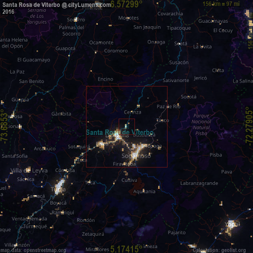
Analysis of Santa Rosa de Viterbo night lights 2016
Square area 10x10 km:
 0.21%
0.21%90-99
1.03%80-89
1.03%70-79
0.21%60-69
2.69%50-59
1.86%40-49
0.41%30-39
0.83%20-29
0.41%10-19
12.19%0-9
79.13%Square area 50x50 km:
0.67%90-99
0.66%80-89
0.63%70-79
0.66%60-69
1.27%50-59
1.23%40-49
0.73%30-39
1.45%20-29
1.35%10-19
7.68%0-9
83.68%Clear (daylight) street map image can be seen on geolist.org.
Map coordinates:
6° 34' 22.8" North, 73° 41' 7.1" West
5° 52' 26.4" North, 72° 58' 55.8" West
5° 10' 26.9" North, 72° 16' 44.6" West
Some cities around Santa Rosa de Viterbo sort by population:
• Sogamoso
18.5 km =11.5 mi,  163°
163°
• Tunja
56.9 km =35.4 mi,  228°
228°
• Duitama
8 km =5 mi, 226°
• Paipa
18.2 km =11.3 mi,  235°
235°
• Soatá
60.9 km =37.8 mi,  32°
32°
• Aquitania
41 km =25.5 mi, 164°
• Belén
14.9 km =9.3 mi, 31°
• Pesca
36.8 km =22.9 mi,  191°
191°
3668447 (p: 6,923)
Sources (retrieved 2019-11-25):
» Earth at Night: Flat Maps 2012, 2016