Retiro night lights from space
Night Light of Retiro (Antioquia) from space (Colombia) Src. Average luminocity for 10x10km area is 15.5847% and for 50x50km: 21.8912%.
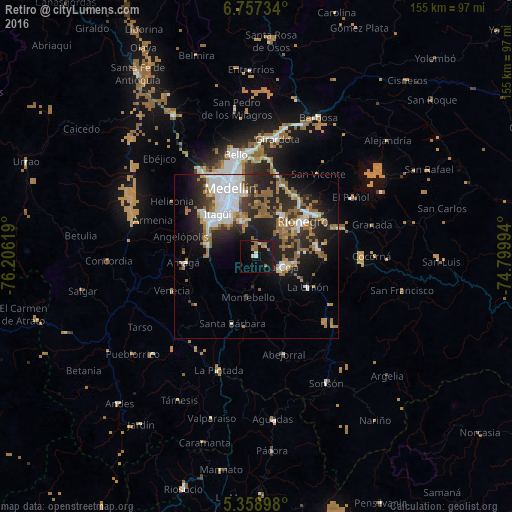
Analysis of Retiro night lights 2016
Square area 10x10 km:
 0.83%
0.83%90-99
1.65%80-89
0.83%70-79
2.48%60-69
1.65%50-59
6.61%40-49
0%30-39
0%20-29
0.21%10-19
26.24%0-9
59.5%Square area 50x50 km:
4.94%90-99
3.46%80-89
1.43%70-79
1.98%60-69
3.83%50-59
5.02%40-49
0.77%30-39
2.19%20-29
8.17%10-19
12.01%0-9
56.19%Clear (daylight) street map image can be seen on geolist.org.
Map coordinates:
6° 45' 26.4" North, 76° 12' 22.3" West
6° 3' 31" North, 75° 30' 11" West
5° 21' 32.3" North, 74° 47' 59.8" West
Some cities around Retiro sort by population:
• Itagüí
17.6 km =10.9 mi,  322°
322°
• Envigado
16.3 km =10.1 mi, 323°
• Caldas
15.1 km =9.4 mi,  283°
283°
• Rionegro
17.9 km =11.1 mi,  53°
53°
• La Ceja
8.3 km =5.2 mi,  111°
111°
• Sabaneta
16.3 km =10.1 mi,  309°
309°
• Carmen de Viboral
18.8 km =11.7 mi,  81°
81°
• La Unión
18.2 km =11.3 mi,  120°
120°
3670849 (p: 7,941)
Sources (retrieved 2019-11-25):
» Earth at Night: Flat Maps 2012, 2016