Puebloviejo night lights from space
Night Light of Puebloviejo (Magdalena) from space (Colombia) Src. Average luminocity for 10x10km area is 32.3355% and for 50x50km: 6.8893%.
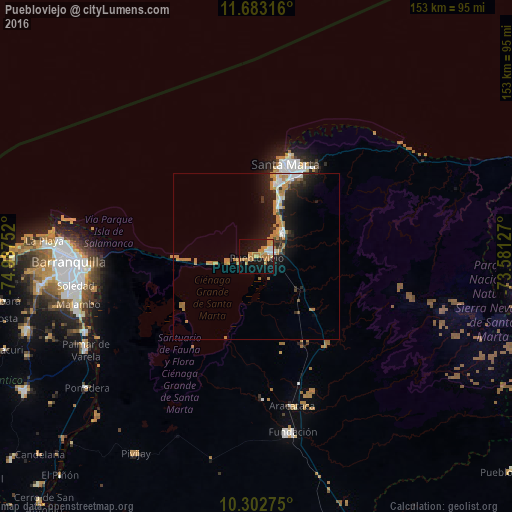
Analysis of Puebloviejo night lights 2016
Square area 10x10 km:
 3.68%
3.68%90-99
2.38%80-89
1.73%70-79
8.66%60-69
16.45%50-59
0%40-49
0%30-39
0%20-29
3.46%10-19
36.8%0-9
26.84%Square area 50x50 km:
0.71%90-99
0.79%80-89
0.28%70-79
1.37%60-69
2.57%50-59
0.13%40-49
0.27%30-39
0.87%20-29
1.84%10-19
6.61%0-9
84.55%Clear (daylight) street map image can be seen on geolist.org.
Map coordinates:
11° 40' 59.4" North, 74° 59' 15.1" West
10° 59' 37.5" North, 74° 17' 3.8" West
10° 18' 9.9" North, 73° 34' 52.6" West
Some cities around Puebloviejo sort by population:
• Barranquilla
54.3 km =33.7 mi,  267°
267°
• Santa Marta
29 km =18 mi,  18°
18°
• Soledad
53.1 km =33 mi,  260°
260°
• Ciénaga
4.3 km =2.7 mi,  69°
69°
• Fundación
53.7 km =33.4 mi,  168°
168°
• Aracataca
45.9 km =28.5 mi, 166°
• El Retén
42.6 km =26.5 mi,  177°
177°
• Sitionuevo
53.4 km =33.2 mi,  243°
243°
3671615 (p: 13,523)
Sources (retrieved 2019-11-25):
» Earth at Night: Flat Maps 2012, 2016