Galapa night lights from space
Night Light of Galapa (Atlántico) from space (Colombia) Src. Average luminocity for 10x10km area is 43.9221% and for 50x50km: 20.6265%.
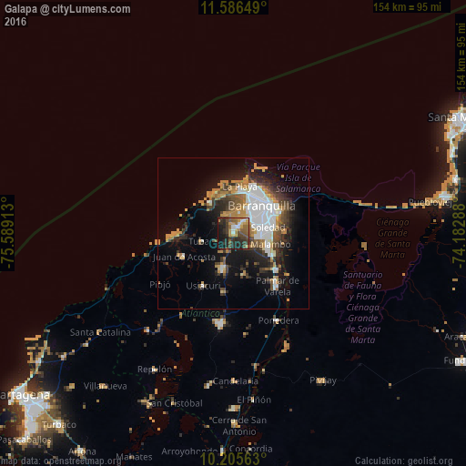
Analysis of Galapa night lights 2016
Square area 10x10 km:
 2.38%
2.38%90-99
5.63%80-89
2.16%70-79
10.61%60-69
7.14%50-59
9.09%40-49
10.82%30-39
11.47%20-29
21.43%10-19
18.4%0-9
0.87%Square area 50x50 km:
4.72%90-99
2.69%80-89
1.1%70-79
3.67%60-69
3.08%50-59
2.05%40-49
3%30-39
3.93%20-29
4.83%10-19
10.18%0-9
60.76%Clear (daylight) street map image can be seen on geolist.org.
Map coordinates:
11° 35' 11.4" North, 75° 35' 20.9" West
10° 53' 48.7" North, 74° 53' 9.6" West
10° 12' 20.3" North, 74° 10' 58.4" West
Some cities around Galapa sort by population:
• Barranquilla
13.9 km =8.6 mi,  55°
55°
• Soledad
13.5 km =8.4 mi,  79°
79°
• Malambo
12.9 km =8 mi,  108°
108°
• Baranoa
11.9 km =7.4 mi,  196°
196°
• Puerto Colombia
12.6 km =7.8 mi,  323°
323°
• Polonuevo
13.8 km =8.6 mi,  165°
165°
• Juan de Acosta
17.8 km =11.1 mi,  244°
244°
• Tubará
10.4 km =6.5 mi,  256°
256°
3682238 (p: 19,732)
Sources (retrieved 2019-11-25):
» Earth at Night: Flat Maps 2012, 2016