Usiacurí night lights from space
Night Light of Usiacurí (Atlántico) from space (Colombia) Src. Average luminocity for 10x10km area is 4.8884% and for 50x50km: 13.2516%.
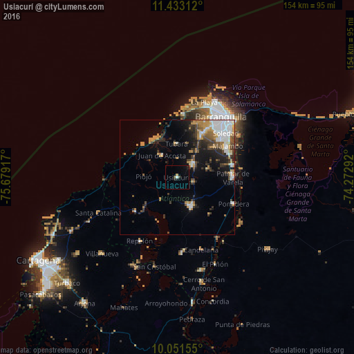
Analysis of Usiacurí night lights 2016
Square area 10x10 km:
 0.41%
0.41%90-99
0.41%80-89
0%70-79
0.83%60-69
0%50-59
0.83%40-49
0.62%30-39
0.21%20-29
1.86%10-19
2.27%0-9
92.56%Square area 50x50 km:
3.11%90-99
1.64%80-89
0.83%70-79
2.42%60-69
1.8%50-59
1.23%40-49
1.69%30-39
2.57%20-29
2.81%10-19
5.39%0-9
76.52%Clear (daylight) street map image can be seen on geolist.org.
Map coordinates:
11° 25' 59.2" North, 75° 40' 45" West
10° 44' 35.3" North, 74° 58' 33.7" West
10° 3' 5.6" North, 74° 16' 22.5" West
Some cities around Usiacurí sort by population:
• Sabanalarga
13.8 km =8.6 mi,  154°
154°
• Baranoa
8.6 km =5.3 mi,  48°
48°
• Sabanagrande
24.1 km =15 mi,  77°
77°
• Galapa
19.7 km =12.2 mi,  29°
29°
• Luruaco
23.7 km =14.7 mi,  233°
233°
• Polonuevo
13.9 km =8.6 mi,  74°
74°
• Juan de Acosta
11.5 km =7.1 mi,  326°
326°
• Tubará
14.7 km =9.1 mi,  358°
358°
3666370 (p: 9,146)
Sources (retrieved 2019-11-25):
» Earth at Night: Flat Maps 2012, 2016