Miranda night lights from space
Night Light of Miranda (Cauca) from space (Colombia) Src. Average luminocity for 10x10km area is 7.039% and for 50x50km: 11.1412%.
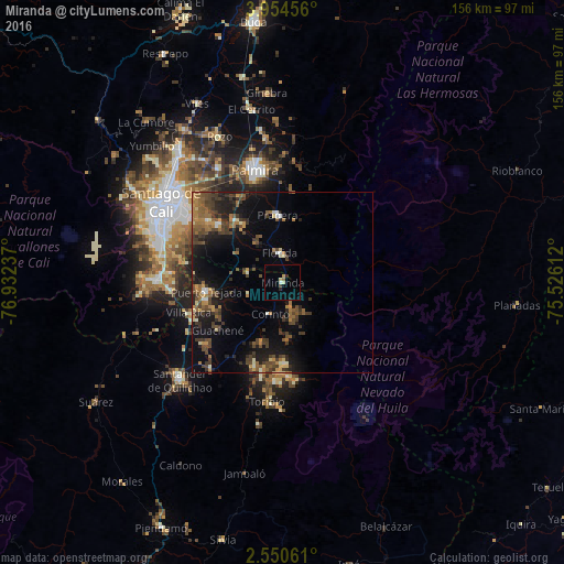
Analysis of Miranda night lights 2016
Square area 10x10 km:
 0%
0%90-99
0.87%80-89
1.73%70-79
0.87%60-69
0.65%50-59
0.22%40-49
0.22%30-39
0.65%20-29
1.95%10-19
0.22%0-9
92.64%Square area 50x50 km:
0.36%90-99
0.74%80-89
0.81%70-79
1.37%60-69
2.12%50-59
2.07%40-49
3.38%30-39
3.17%20-29
2.76%10-19
8.43%0-9
74.78%Clear (daylight) street map image can be seen on geolist.org.
Map coordinates:
3° 57' 16.4" North, 76° 55' 56.5" West
3° 15' 10.2" North, 76° 13' 45.3" West
2° 33' 2.2" North, 75° 31' 34" West
Some cities around Miranda sort by population:
• Palmira
32.9 km =20.4 mi,  345°
345°
• Puerto Tejada
20.9 km =13 mi,  263°
263°
• Florida
7.7 km =4.8 mi,  355°
355°
• Jamundí
34 km =21.1 mi,  271°
271°
• Pradera
18.8 km =11.7 mi, 354°
• Candelaria
21.6 km =13.4 mi,  322°
322°
• Corinto
9.6 km =6 mi,  202°
202°
• Caloto
31.2 km =19.4 mi,  219°
219°
3674702 (p: 13,223)
Sources (retrieved 2019-11-25):
» Earth at Night: Flat Maps 2012, 2016