Chocontá night lights from space
Night Light of Chocontá (Cundinamarca) from space (Colombia) Src. Average luminocity for 10x10km area is 2.9008% and for 50x50km: 2.7336%.
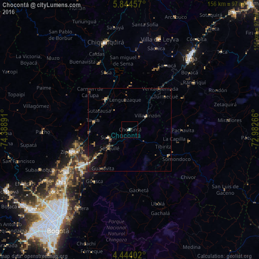
Analysis of Chocontá night lights 2016
Square area 10x10 km:
 0%
0%90-99
0.83%80-89
1.65%70-79
0%60-69
0%50-59
0%40-49
0.83%30-39
0%20-29
0%10-19
0%0-9
96.69%Square area 50x50 km:
0.11%90-99
0.16%80-89
0.36%70-79
0.33%60-69
0.49%50-59
0.37%40-49
0.53%30-39
1.05%20-29
0.51%10-19
1.59%0-9
94.5%Clear (daylight) street map image can be seen on geolist.org.
Map coordinates:
5° 50' 40.5" North, 74° 23' 20.1" West
5° 8' 40.8" North, 73° 41' 8.8" West
4° 26' 38.5" North, 72° 58' 57.6" West
Some cities around Chocontá sort by population:
• Zipaquirá
37.9 km =23.5 mi,  248°
248°
• La Mesa
28.9 km =18 mi,  297°
297°
• Villa de San Diego de Ubaté
23.3 km =14.5 mi,  321°
321°
• Garagoa
36.4 km =22.6 mi,  100°
100°
• Guateque
28.2 km =17.5 mi,  123°
123°
• Tocancipá
32.1 km =19.9 mi,  231°
231°
• Villapinzón
12.8 km =8 mi,  51°
51°
• Nemocón
22.9 km =14.2 mi, 248°
3686422 (p: 7,592)
Sources (retrieved 2019-11-25):
» Earth at Night: Flat Maps 2012, 2016