Tocancipá night lights from space
Night Light of Tocancipá (Cundinamarca) from space (Colombia) Src. Average luminocity for 10x10km area is 47.2975% and for 50x50km: 17.0183%.
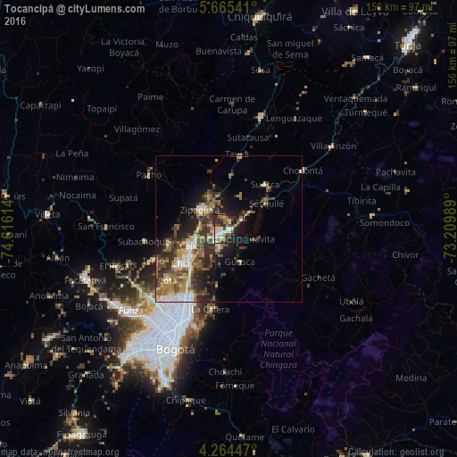
Analysis of Tocancipá night lights 2016
Square area 10x10 km:
 6.4%
6.4%90-99
11.57%80-89
4.75%70-79
3.51%60-69
10.12%50-59
5.79%40-49
4.96%30-39
12.4%20-29
14.88%10-19
22.73%0-9
2.89%Square area 50x50 km:
2.16%90-99
2.2%80-89
1.48%70-79
2.56%60-69
3.09%50-59
3.28%40-49
3.02%30-39
4.31%20-29
5.21%10-19
6.71%0-9
65.97%Clear (daylight) street map image can be seen on geolist.org.
Map coordinates:
5° 39' 55.5" North, 74° 36' 58.1" West
4° 57' 55.1" North, 73° 54' 46.8" West
4° 15' 52.1" North, 73° 12' 35.6" West
Some cities around Tocancipá sort by population:
• Zipaquirá
12 km =7.5 mi,  301°
301°
• Chía
20 km =12.4 mi,  233°
233°
• Cajicá
13.8 km =8.6 mi,  247°
247°
• La Calera
27.9 km =17.3 mi,  192°
192°
• Sopó
7 km =4.3 mi,  203°
203°
• Cota
26.8 km =16.7 mi, 229°
• Chocontá
32.1 km =19.9 mi,  51°
51°
• Nemocón
12 km =7.5 mi,  18°
18°
3666997 (p: 6,027)
Sources (retrieved 2019-11-25):
» Earth at Night: Flat Maps 2012, 2016