Oberuzwil night lights from space
Night Light of Oberuzwil (Saint Gallen) from space (Switzerland) Src. Average luminocity for 10x10km area is 6.3949% and for 50x50km: 5.3808%.
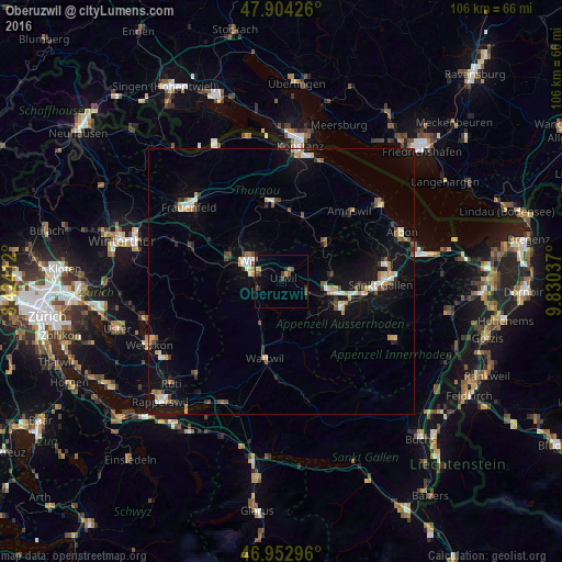
Analysis of Oberuzwil night lights 2016
Square area 10x10 km:
 0%
0%90-99
0%80-89
1.42%70-79
0.28%60-69
1.14%50-59
0.57%40-49
2.56%30-39
1.85%20-29
0.99%10-19
2.27%0-9
88.92%Square area 50x50 km:
0.52%90-99
0.67%80-89
0.69%70-79
0.65%60-69
0.63%50-59
0.43%40-49
0.78%30-39
0.65%20-29
0.78%10-19
4.82%0-9
89.38%Clear (daylight) street map image can be seen on geolist.org.
Map coordinates:
47° 54' 15.3" North, 8° 25' 26.8" East
47° 25' 50.7" North, 9° 7' 38.1" East
46° 57' 10.7" North, 9° 49' 49.3" East
Some cities around Oberuzwil sort by population:
• Gossau
9.7 km =6 mi,  100°
100°
• Wil
7 km =4.3 mi,  299°
299°
• Herisau
12.5 km =7.8 mi,  113°
113°
• Uzwil
0.8 km =0.5 mi,  39°
39°
• Flawil
4.7 km =2.9 mi,  115°
115°
• Kirchberg
6.9 km =4.3 mi,  251°
251°
• Wattwil
14.9 km =9.3 mi,  191°
191°
• Sirnach
10.4 km =6.5 mi,  289°
289°
2659331 (p: 5,616)
Sources (retrieved 2019-11-25):
» Earth at Night: Flat Maps 2012, 2016